


2023-03-17_18h57m53_le-beaucet-2019 (1)

FLORENSAC
User
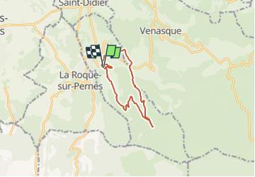

Length
10.3 km

Max alt
444 m

Uphill gradient
380 m
Km-Effort
15.3 km

Min alt
220 m

Downhill gradient
376 m
Boucle
Yes
Creation date :
2023-03-17 17:57:53.728
Updated on :
2023-03-17 17:57:56.867

FREE GPS app for hiking
 SityTrail
IGN / Geographical institutes
SityTrail Plus
The world is yours!
About
Trail of 10.3 km to be discovered at Provence-Alpes-Côte d'Azur, Vaucluse, Le Beaucet. This trail is proposed by FLORENSAC.
Positioning
Country:
France
Region :
Provence-Alpes-Côte d'Azur
Department/Province :
Vaucluse
Municipality :
Le Beaucet
Location:
Unknown
Start:(Dec)
Start:(UTM)
669932 ; 4872194 (31T) N.
Comments